
Capture Accurate Views From Above
High-resolution imagery and reliable turnaround for every project you need documented.
Taft, CA
93268
- Mon - Fri
- -
- Saturday
- Appointment Only
- Sunday
- Closed
Elevate Your Project with Professional Aerial Imaging
FAA-certified operations with dependable service across Bakersfield and beyond
661 Aerial Ops is a local drone service provider based in Taft/Bakersfield, bringing professional-grade equipment and certified expertise to projects across the Central Valley. Whether you need construction documentation, property visuals, or safety-focused inspections, aerial imaging offers a perspective that ground-level work simply can't match. The ability to see the full scope of a site or structure changes how you plan, assess, and communicate progress.
You'll receive imagery that's sharp, usable, and delivered on schedule. From the initial conversation to the final file handoff, you'll know what to expect and when. Each flight is planned with your objectives in mind, whether that's tracking site changes over time, preparing marketing materials, or conducting a visual assessment without scaffolding or ladders.
661 Aerial Ops handles everything from large-scale mapping projects to targeted inspections and promotional content. The focus stays on accuracy, safety, and providing you with visuals that serve a clear purpose. Every project benefits from the same attention to detail and professional standards.
Reach out to discuss your project and schedule a flight that fits your timeline.
Professional Drone Operations You Can Trust
FAA Part 107 certified service delivering clear results across multiple industries.
Understanding what you'll receive and how the process unfolds makes it easier to integrate drone services into your workflow. Every flight begins with a conversation about your goals, site access, and deliverable format. From there, the operation is coordinated around weather windows, airspace clearances, and any on-site activity that might affect timing. You'll have a clear sense of when imaging will occur and what format your files will arrive in.
Professional drone operations mean more than just launching a camera—it's about planning each flight to capture the angles and details that matter most to your project. Documented steps and consistent coordination ensure nothing is overlooked, and you're kept informed as conditions or scheduling shift.
Here's what drone services bring to your projects:
How Aerial Documentation Supports Your Work
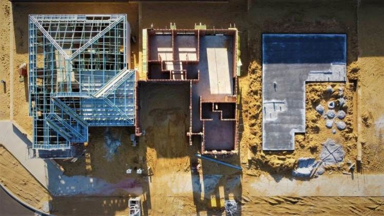
Construction site documentation that provides accurate overhead views for tracking progress and coordinating trades
Mapping and surveying capabilities that deliver precise data for land analysis and planning
Inspections of towers, roofs, and water tanks that prioritize safety by eliminating the need for personnel to work at height
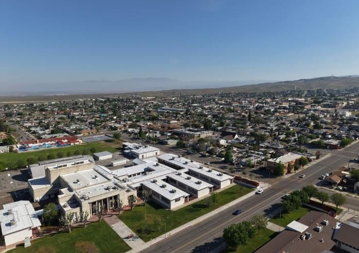
Real estate, event, and business visuals tailored to the unique landscape and development patterns around Bakersfield, Taft, Shafter, Wasco, Tehachapi, and Delano
Get in touch to request a quote and review how aerial imaging can support your next phase.
Certified Service Built on Dependability
661 Aerial Ops operates under FAA Part 107 certification, which means every flight adheres to federal safety and airspace regulations. Operating across Bakersfield and surrounding communities requires familiarity with local conditions, access considerations, and the ability to adapt when project needs shift. That local grounding translates into smoother coordination and fewer surprises.
Professionalism in this field comes down to showing up prepared, delivering what was promised, and standing behind the quality of the work. Whether it's a one-time shoot or ongoing documentation over months, you can count on the same level of care and accountability from start to finish.
Schedule your flight and see how professional drone operations can deliver the perspective your project deserves.